River Gauges
Downton Iron Bridge
This is a new area which aims to show on a single page the information from the key river gauges of the rivers that feed into the River Avon at Downton. It takes usually a week for changes in river levels on the up-stream rivers to reach Downton’s Iron Bridge. The flows and gauges are outlined on the diagram below.
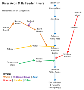
For each River the key gauges are shown below. The gauge nearest to Downton comes first followed by gauges upstream. To see more details click the name of the gauge and then click the ‘River Level’ tab. Clicking Graph options to change what gets displayed and over what timeframe. Each river is shown in a column.
If you want to see this information on your Smartphone then install and setup the RiverApp ![]() – available for iOS and Android
– available for iOS and Android